Stuff I Know

Just stuff by me about me and my life, such as it is.

Thursday, August 30, 2007

Things I Have Learned ...

... Riding a bicycle in Beijing.

  • You shouldn't look at the girls in skirts riding the opposite direction.
  • You shouldn't look at the girls in skirts walking, either. (All the girls are just too distracting.)
  • Don't panic! It may feel disconcerting with all those people riding so close to you, but they are professionals at it.
  • Even with that taxi about to clip your handlebars or in the process of cutting you off, don't panic!
  • The lights, the police blowing whistles and the guys waving flags aren't very effective when it comes to traffic control. The seem to be looked on more as guidelines, really.
  • That road you just passed that looked like the one you wanted, more than likely was.
  • Your personal space on a bicycle in Beijing extends only as far as your handlebars and front and rear tires. And sometimes not even that far.
  • It may all feel and look dangerous, but it all seems to work pretty well, actually.
  • Bicycle lanes are a good thing to have, even if you do have to share them with cars both parked and moving.
  • The people on electric bicycles seem to have a bit of a superiority complex over people on regular bicycles, as evidenced by the frequent use of their fancy electric horns.
  • A foreigner on a bicycle apparently isn't such a big deal in Beijing. (Compare this with Korea where even in bigger cities, parents in cars will point you out to their children as they pass.)
  • A squeaky bicycle may seem annoying at first but it lets others know you are coming up on them. Always a good thing when you are not sure of the proper "cutting off" etiquette.

All in all it wasn't a bad experience. My years of dodging road traffic served me well in Beijing. It was good to get on a bike again. Even a bike like that.

Labels:

Thursday, August 23, 2007

Leaving On a Jet Plane ...

And I really don't know when I will be back again.

Hey, did I mention I will be traveling soon? Yep, I have decided to take a break from work for a while and see more of the world.

I will start in China, see some parts of South-east Asia that I have missed, and then into India. After that, where I go is anyone's guess. This trip may be a long one, possibly six months.

I will try to post some entries or pictures here from time to time, but I can't guarantee how often.

Before I go, let me leave you with a little bit more of Korea. Below are some of the pictures I have taken here over the years.There are more on my public Picasa site. Go have a look.

More photos!

Wish me luck on my journey. Oh, and if, somehow, I happen to get abducted along the way. I don't negotiate with kidnappers. And you shouldn't bother to either.

Remember ... Jama rek.

Labels: , , ,

Friday, August 17, 2007

Yet More Maps

I thought I would try and get a few more things that I have been working on out before I finally lose my computer access.

Here is a Google Earth file of all the subways in South Korea. 

KMZ files require Google EarthSouth Korean Subways

The original work is not mine, but comes from the fine group of people at the Google Earth (Keyhole) forum. (Can't seem to find the actual post at the moment, sorry.)

It has all the lines in Seoul, Daejeon, Daegu, Busan, and Gwangju. It also includes platform locations and station exits for many stations. Of course the subway system is a work in progress, so there are a few mistakes and omissions, but nothing major. 

Now this might be useful on a GPS receiver also. Not for when you are actually on the subway, but for when you are above ground. If you are wandering the streets of any of these cities and want to find the nearest subway entrance, just pull out your trusty GPS unit and do a "Find" for POIs and viola. You are magically pointed to the nearest subway entrance.

I cleaned up the file some and converted it into something that will work on a Garmin GPS unit. It is transparent so it won't cover up your other loaded maps. I will give you the image so you can load it on your GPS, but take note. I had some problems making this work with MapSource. It would only work correctly if I sent it directly to the GPS unit. Also, you must use the provided type file to get the subway lines the right color. If you know how to use SendMap, then you'll have no problem adding this image to your GPS. Here is the zip file which includes the image and type file.

 Subways image and type files.

One more image file for you. This one I just did to teach myself how to do it and to see if everything worked OK. It is a contour map of the area around Andong-shi. It has major and minor contours at 20 meter intervals. The data comes form the Shuttle Radar Topography Mission program which mapped most of the Earth's elevations. The data for Korea was only available at 90 meter resolution, which is not the best, but it was all that I had to use at the time. It is also a transparent map. If you want to see those mountains ahead of you on the map, download this file and use SendMap to load it onto your GPS unit.

Andong-shi contours image file. This is a large file (+10 Megs) so I've put it on a file hosting site. If it disappears, let me know and maybe I can send it to you.

Labels: , , , ,

Tuesday, August 14, 2007

More Maps

Since I was talking about Google Earth a bit ago, let me continue. Google Earth is a great program. It lets you see the world from a whole different perspective. You should try it out. There are versions in several languages, even Korean,

Unfortunately, the images are only as good as the data and, for South Korea, the data is certainly lacking. Look at this ...

The left is Las Vegas, the right is Andong

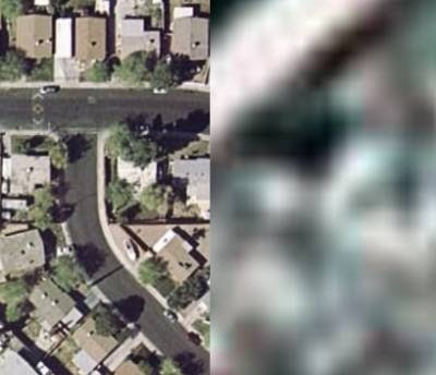
On the left is the image data for where I grew up, Las Vegas, USA. On the right is the image data for where I live now, Andong, South Korea. Now not all of Korea looks like Andong. The major cities have some very nice high resolution imagery. Unfortunately most of South Korea is pretty low resolution (a lot of North Korea is pretty hi-res, though).

And it is not just image data; road data suffers also. Most western countries have excellent road data which displays in Google Earth and Maps. Even some eastern countries have good data. In fact, South Korea is one of the few industrialized nations which doesn't have good road data. Heck, even India has good road data. Sure you can see some roads in Korea, but what is displayed (as of this post) is rather laughable. Only the major highways are shown and then even not all of those. And the positions for those roads are only good if you are viewing form about 250 km up in the sky (Actually, now, no road data is being displayed for Korea.).

Part of the reason for the great road data in the USA and Canada is the fact that information about the roads is gathered by the government using public funds, so the data becomes  public property. In India they have the legacy of British colonization from which they inherited a system of data organization. Also Google is working with the local population in India to help update road data in some cities.

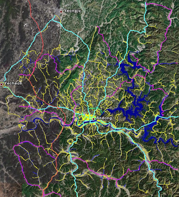
I figure I can help Google in the same way. Use my local knowledge of the place to provide far better maps of Korea than what is available at the moment. Well, at least my small portion of Korea. So here it is. I give you Andong, with roads (and rivers and lakes and more).

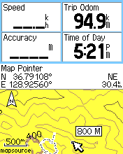
 I've even got data for when you zoom in close.

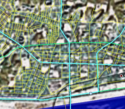
 In addition to the road data, some lakes, rivers, trails, and interesting locations are there for you to see. This was all done mostly through capturing location data with my GPS receiver as I rode around the city on my bicycle. Other information was entered from scanned maps and such. I am offering it here for anyone to use. Take the data, use it, modify it, do whatever you want with it. Just make sure you read the Creative Commons copyright information I have for this site and follow the restrictions. Here is the Google earth file for you to download.

KMZ files require Google Earth

 Andong-Area

A few notes about the data ... the rivers, lakes, and streams were all taken from scanned map data, so possibly the outlines and waterways may not match up exactly with the images from Google Earth since the image data is from a different time period. Every road or trail shown is passable on a bicycle and most of them are drivable. However, paths listed as trails would likely be bike or walking only. Unpaved roads may be just that or they may be paved; even so you should probably treat them as trails because they are usually single lane farm roads in poor condition. Pedestrian roads, one way roads, restricted roads or intersections and similar are not listed as such. This is just path data. As always, I just provide you with the data. What you do with it is your business. I can not be held responsible if you get into trouble using the data from this site.

Now you may be saying to yourself... "Wow, this is a great resource. Now if I could only put this on my Garmin GPS receiver it would be really useful." Well you can because that is the really the whole reason I collected the data in the first place.

Here is the source file, Andong-Area-with_points.MP, for GPSMapedit. Take it, correct it, add to it.

If you would rather just have the image file to use with SendMap, here you go. Andong-Area-with_points.img

You should right-click those files and choose "Save as ..." to download. The data is probably in its final for. I doubt I will be making any additions to it. You can always find it here, or have a look at Mapcenter were you can find lots of map data. In fact, you might want to use the Mapcenter.com img instead of the one here. The one at Mapcenter has POI (points of interest) indexing.

Labels: , , , , , ,

Thursday, August 09, 2007

Mileage

No, I haven't posted in a while, but I haven't been all that lazy.

One thing I have been doing is riding my bike. With the consecutive streak ending about two weeks ago, for ten weeks I went on ten rides. The total distance (Is there a equivalent metric word for 'mileage'?) for those ten rides was 1024 km.

That's about about three times the distance from Seoul to Pusan and close to four times the distance from east coast to west coast. Unfortunately I was not traveling in a straight line. Most of the rides were loops out of and back into Andong. Much of the area I have covered before, but I did see some new interesting scenery.

Here is an image which shows the different routes I took.

KMZ files require Google Earth If you want to explore the routes more closely, you can download the KMZ file and peruse in in Google Earth. (If aren't using Google Earth yet, you really should be.)

If you want to see a Google Maps version, go to this page. Note that the routes are less precise than the Google Earth version and the map may slow your computer down if you have an old computer. Also, only a small area west of Andong has high resolution imagery. Have a look, though.

If you want to follow in my footsteps, the route labeled "06/30/07" runs through some pretty nice scenery. Canyons, rivers, valleys, mountains, the whole gamut. It is really nice after a rain shower when the air has been cleaned of all the haze. The green can certainly be amazing here.

Labels: , , , , ,