The Big Picture
OK, here is another update on all the bicycle rides I take here around Andong. If you haven't seen the earlier postings, what I do is strap my Garmin eTrek unit to the handlebars of my bike (I have kind of MacGyver-ed my own mount) and go for a spin around the countryside, all the while recording my position via GPS satellite. When I get home, I download the data to my computer and display the maps in any number of various ways. All good fun!

I have displayed all the recorded rides this time, so things are looking pretty colorful. As you can see (click for a bigger image) I have covered a lot of territory. I don't have a total distance for all these rides handy, but the last one I took, that southern yellow east-west line, was just over 88 km. all the way around. Maybe some day I'll post some statistics on the rides.
If you want to have a closer look at some of the rides, I have a Google map for you of the last five I took. Click this link and a Google Map will open in a new window. Once there, you can scroll around by clicking and dragging the map, zoom in or out with the scale on the side, and turn individual rides on or off by clicking on the colored name.
Something interesting ... Find the spot on the dark blue trail, 23-April, where I cross the lake/river - straight to the north. Center the map on that spot by double-clicking there. Then click on the zoom scale between the 5th and 6th mark from the top. (Note: if the trail doesn't redraw after the zoom, you can make it redraw by clicking the trail name off then back on. It might be slow.) With the trail off, you can see the bridge. With the trail on, you can see where it looks like I went past the bridge and down into the lake.
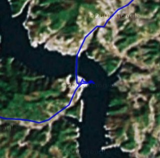
I assure you I didn't ride my bike into the lake. I am not sure when these images were taken, but the lake is not as wide as it looks in the picture. There is a boat ramp there, and actually the lake is about half the width you can see in the picture. I don't think the lake has been up to these levels in quite a while.
If you want to see the rides in 3-D you can download the Google Earth KMZ file. Just click on this link  and the file will load and start up Google Earth. Zoom, pan, tilt, and view to your heart's content.
Labels: bicycling, Google Earth, GPS, Korea, maps
posted by Alimamo @ 12:40 PM
![]()
![]()


0 Comments:
Post a Comment
<< Home