Now for something a little different ...
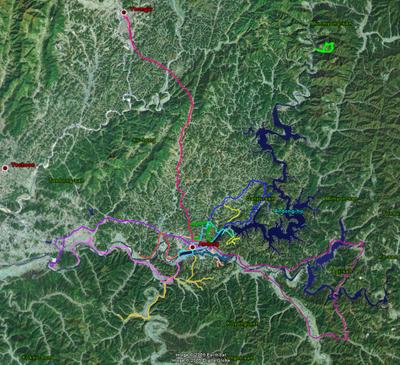
This is something I have been wanting to do for a while, but it has taken me some time to put it all together. I have mentioned before in this blog how I go riding in the countryside around Andong. That is, in fact, how I get most of my photographs (so if you don't like the photos you can blame it on my location ;-)) . I have shown you the pictures from my rides, and now I can show you where I have actually ridden.

(You can see a different shot of this map with some perspective here.)
Thanks to a Garmin eTrex unit, the amazing program Google Earth, and a lot of time and patience, you see before you a map of some of my rides. There are a couple specific rides I do regularly that aren't on this map due to dead batteries, lost data, or my own forgetfulness. I'll ride those again and put them on the map eventually.
If you have Google Earth, and you really should if you have a fast connection, you can click on the link below and load a file into the Google Earth program that will allow you see the rides in more detail. You'll be able to zoom in and out, pan around, turn off individual rides, and even play a tour of one or all of the rides. Just so you know, because of the limited resolution of data for this area, the tour isn't all that interesting. But if you do have Google Earth, click the link below and enjoy.
SomeRides.kmz
For those of you without Google Earth, there is the possibility you can still see a user adjustable version of the map through Google Maps. I say possibility because I have been having a lot of trouble getting this working. I load the page up to a web host (free sites because I am cheap) and it seems to work. But then I try to access the page again and it is either broken, missing, or I can't up load a similar file to fix it. I think these free web hosts don't like me running Google Maps through their sites. Here is the link if you want to try.
Google Maps version. (edit: sorry, it is not working at the moment)
There are a couple of problems with the Google maps version. The tracks don't exactly line up with the maps, things should be shifted south and east a bit. The page is a bit slow to load and the images even slower. And there is an extra track running north and to the east a bit, up to the short mountain track. This is due to a problem converting the GPS data. The conversion program expects a continuous track. But since I didn't turn the GPS unit on until I got to the mountain, it makes its own connection between tracks. Much thanks to Mark McLaren's Weblog for the tools to make things work (when they did work).
I would eventually like to make the maps linkable with the geotagged photos. From what I have seen around the web, it is doable, but that will take some work (and possibly my own domain). However, right now, the Garmin eTrex has a rather annoying flaw that makes geotagging photos more of a chore. Whenever you save a track file internally the timecodes for the GPS data just disappear. They are not saved. Without the timecodes you can not use the GPS track to geotag photos. This means you have to run one long active track, never saving, or download the active track data after each trip. If you stop and start the GPS unit at different locations, that makes for rather disjointed track data. If anyone has a suggestion for a good cheap GPS unit that saves timecode data and altitude internally, please let me know.
If you just want to see where I live in an interactive manner, rather than dragging out the old atlas, then click the image below.
This is a tool from Neave Lab that seems to make Google Maps and Microsoft's Virtual Earth easier to use. When the page loads, just use your mouse wheel or the slider to zoom in and out. If you don't move the map around and zoom almost all the way in, the little plus "+" is positioned right over my apartment building. If you are zoomed out and it says "No imagery at this level" then it was just a bad load. Zoom in or out again and let the images reload.
Go ahead and see if you can fin your own house. Fun, isn't it. If you find your house, zoom in to a reasonable level, click the "Link to this location" in the lower right corner. The page will reload and in the address bar in your browser will be a direct link to that spot. If you have some time, copy that address and post it in the comments on this blog to let me know where you are from. Here is the house I grew up in:
http://www.flashearth.com/?lat=36.184869&lon=-115.212578&z=18&r=0&src=0
"Luck is being in the right place at the right time, but location and timing are to some extent under our control."
~ Natasha Josefowitz
"And above all, watch with glittering eyes the whole world around you because the greatest secrets are always hidden in the most unlikely places. Those who don't believe in magic will never find it."
~ Roald Dahl
Labels: Korea


2 Comments:
Your adventure's blog it's great!.
Regards from Spain
I 'll be come the next time
Nice post, regards from Spain.
See you at internet.
;-)
Post a Comment
<< Home